Storms result in record rainfall, water rescues & property damage
Clean up, county damage assessment underway
By Amanda Lubinski
Digital Content Director
Multiple water rescues occurred in Grundy County this weekend after severe storms brought record rainfall, large hail, a tornado warning and flood conditions to Trenton and the surrounding area this past weekend.
The National Weather Service and Grundy County Emergency Management issues several alerts this weekend for severe thunderstorms for the county and a rare flash flood emergency for Trenton. The first severe thunderstorm warning came in before 4 p.m. Saturday, May 16. By 9:35 p.m. Saturday, the NWS issued a flash flood emergency for Trenton after upwards of 7.5 inches of rain fell.
Water rescues & damage
“Emergency managers say roads are flooded and even buckling in spots, with another round of torrential rain still moving in,” reported the weather service.
The flooding led to two water rescues, electrical arcing and another call for a vehicle being submerged in water Saturday. The first water rescue occurred around 5:38 p.m. Saturday when Trenton Fire Department responded to a vehicle partially submerged near Dino’s Diner.
“Firefighters assisted the motorist and their dog from the submerged vehicle to the roadway. Trenton PD further assisted the motorist,” reads the department report.
The second water rescue occurred around 8:22 p.m. when Grundy County Rural Fire Protection District responded to a person in a vehicle that was partially submerged in flood waters on Pauper Grade Road. A water rescue boat was deployed and an ambulance crew was able to assist the motorist out of the floodwaters.
No injuries in either water rescue were reported.
The flooding also caused electrical arcing and smoke to emit from an electrical meter around 6 p.m. Saturday at 603 Wiggins.
“Firefighters monitored the situation until TMU arrived to disconnect the meter. Arcing was caused by water intrusion into the meter box,” reads a report from the Trenton Fire Department.

A third vehicle partially submerged in water was also reported to Trenton Fire Department Saturday. The vehicle was located around 8 p.m. in a ditch near Trenton Middle School’s parking lot.
“Upon arrival, the motorist had self-extricated and no assistance was needed,” reads the fire department report.
While no injuries have been reported, the storms wreaked havoc on property throughout the area with residents taking to Grundy County Emergency County Management’s Facebook to report issues.
“Madison St in Trenton will 100% need replaced between 17th and Scott,” commented Tyler Willey.
“Galt (Apartments) had a whole building flood. All four (apartments) are soaked 100%. Three families are in a bad way,” reported Chris Bonnett.
After the storm
Trenton City Administrator Matt Harline said the storms resulted in the closure of roads in the city through Sunday.
“The street closures were removed on Sunday. The airport runway is closed due to damage to some of the lights. It is available for emergency landings,” he told the Telegraph Monday.
Harline said it’s hard to pinpoint where in the city the most damage was sustained.
“We are finding out about flash flood damage to property, but hail and wind damage seemed to be worst east of the UPRR tracks with the hardest hit are east of U. S. Highway 65. The wind and hail were severe in the south half of Trenton. Of course, Crowder Park was hit hard as was Laredo. But that is outside of the city,” said the Trenton city administrator.
Many area residents reported on social media they had vehicle and residential damage from hail upwards of multiple inches in size, with some reporting hail the size of baseballs.
“Lots of hail damage to folks that (were) attending a wedding at the Black Silo Winery tonight,” Tara Lynn wrote in the comments of Grundy County Emergency Service’s Facebook page.

Green Hills Animal Shelter also took to social media to report “slight” damage at the facility from the storms.
“There’s a few spots where the roof was starting to leak. It was very scary for the dogs,” reads a shelter Facebook post.
According to KTTN, the water treatment plant on the west edge of Trenton recorded 8.8 inches of rainfall during the 24-hour period ending at 7 a.m. Sunday, establishing a new one-day rainfall record for the city.
“Grundy County Emergency Management Director Glen Briggs reported that the previous precipitation record for Trenton was set Sept. 7, 1914, when 6.67 inches of rain were recorded,” reported the radio station.
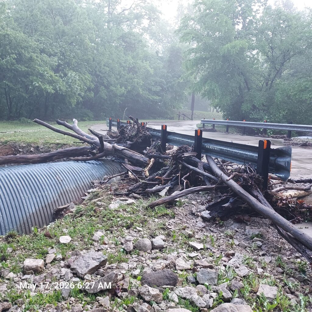
On Sunday, officials with Crowder State Park asked residents not to enter the park until roadways could be cleared. Images shared to social media from around 5 a.m. Sunday show large tree limbs, logs and rocks blocking roadways.
“Reminder, the Crowder State Park campground and trails are closed until Thursday, May 21, as park staff work to make the areas safe,” the park posted to its Facebook page on Monday, May 18.
The public should stay away from the campground as park staff work to make the culvert safe ahead of the Memorial Day holiday weekend, park officials told the Telegraph Monday.
“After the trails dry, we could use help with getting them back to the awesome condition they were in last Friday,” said park officials when asked if there is any help the public can provide to aid park clean up.
In the wake of the storm, Hostetlers Market, was closed Monday.
As of Wednesday, May 20, parts of Trenton Municipal Airport remained closed as result of the storm.
“Runway 18/36 is temporally closed due to debris along the edge of the runway. Runway 18/36 will remain closed until city forces can remove all obstructions and mud from the edge and surface of the runway. Several runway lights including Precision Approach Path Indicators and Runway End Identifiers have been damaged due to flooding. Because of the damage to these lights, the airport will be limited to daytime flying only until all lights have been repaired,” Airport Manager Wes Barone told the Telegraph.
Resident input needed
Grundy County Emergency Management is now working to assess damage and seeks residents’ help.
“We are starting the process to collect information for a preliminary damage assessment to determine if the county has enough damage to potentially reach any state or federal disaster declaration,” a post on the emergency service’s Facebook page states.
Reports can be made using the google form at https://forms.gle/7cxwREYnnuVAQ5WAA.
“We understand that sometimes you are not comfortable with sharing addresses with people, but it is important we have addresses for documentation toward the damage assessment,” reads the service’s Facebook post about the form. “Second, there is no guarantee that any federal or state assistance will be available, but we will not know until we have a good picture of the extent and costs of this event so please help us out and give us your damage reports.”
In addition, Harline said if Trenton residents had a sewer back up due to the storm, they should contact their insurance agent first, then the city.
“If their insurance agent says that they are not covered, they can get an insurance claim form from the city and complete it. It is likely that they will be denied as the storm was so heavy that the city could not have been reasonably been expected to prevent a back up, but the information collected for that form will be useful if the storm is declared a natural disaster,” he said.